Saturday, March 26, 2016

Cathedral Hills Park -- Wild Rose & Outback Loop Trails


March 23, 2016

Since it is Spring Break week, we decided to head over to Cathedral Hills Park and see all the wildflowers that are making their Spring Break -- literally millions!!!

Time to get out and hike!
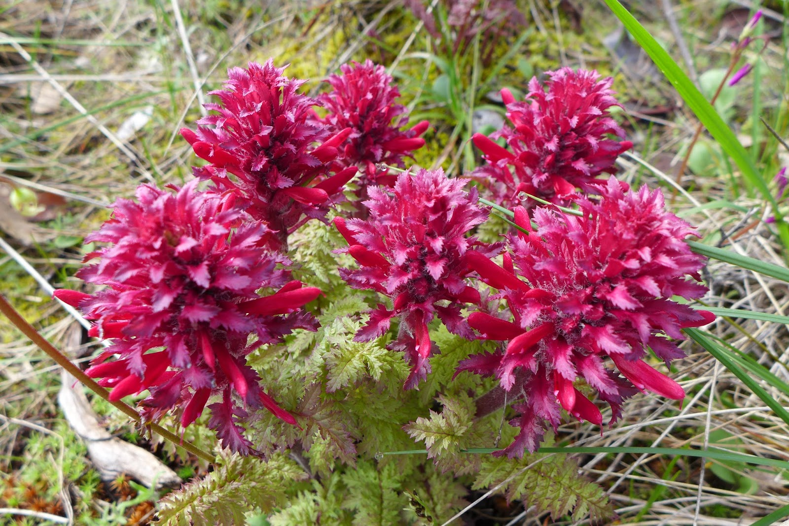
We started off by driving highway 238 from Jacksonville to the park in Grants Pass.  It is such a nice scenic drive at this time of year with all the farms and animals.  We even saw a rafter of wild turkeys!  Once we reached Espy road it was just a short drive to the parking lot at this trailhead (the park has 3 trailheads) and there were already lots of cars. It didn't take long to catch sight of the thousands of Indian Warriors that come out at this park in Spring.

Indian Warrior


A clump of Indian Warriors


We decided to hike two routes that have been our favorites over the last few years, so the hikes were not new,  but the sight of all the wildflowers was amazing!

Saxifrage
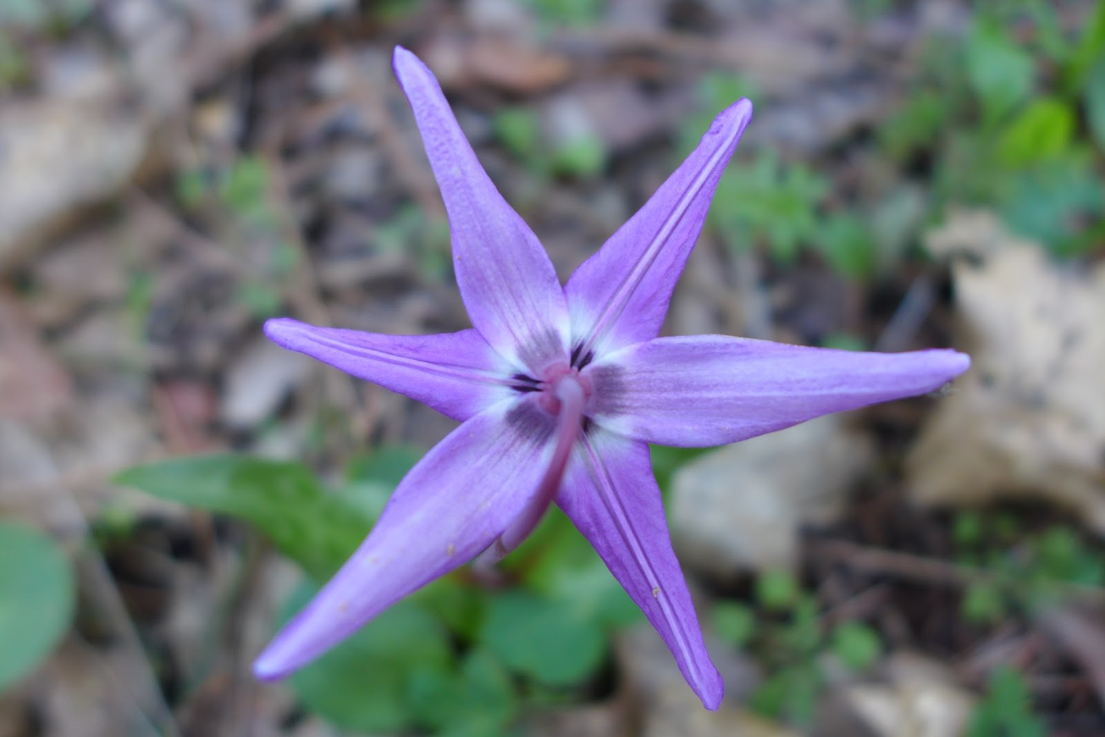
The first loop consisted of the Backside Loop, the W trail, and the Wild Rose loop.  We hiked by patches of Indian Warriors, Shooting Stars, Buttercups, Saxifrage, Houndstongue, Desert Parsley and Fawn Lillies en route to the Wild Rose loop and enjoyed a couple of viewpoints of the valley.  Most of this hike was shaded and in amongst the trees, so in addition to wildflowers we were treated to lots of green ferns and moss and encountered many small creeks crossing the trail.  The Wild Roses are not in bloom this early, so this loop makes a great hike later in Spring when the other wildflowers are done blooming.

Fawn Lilies


Shooting Stars


One viewpoint on the W trail.  Snow capped mountains in background

Desert Parsley


Fungus thingy
We also saw a lot of poison oak.  Yes, staying on the trail is a good rule to follow when hiking here, unless you really want to experience the effects of poison oak contact after your hike.

Poison Oak was plentiful along trails at Cathedral Hills Park

After completing this first hike (3.4 miles), we took a break back at the trailhead to get refueled.  The park has picnic benches/tables available as well as benches out on the trails where you can sit down, take a break, and enjoy the beauty and quiet.


Trail signs are everywhere and easy to follow.

View of Outback trail.
We then hiked the Outback Loop with a side trail on the Ponderosa Pine Loop, a total of another 3.8 miles.  We have hiked this loop in both directions and prefer to hike it counterclockwise.  This loop had even more creeks crossing the trail and there were lots of muddy spots along the trail as well.

One of the flooded areas on the Ponderosa trail

View of the hills along the trail
Eventually the trail heads up to the ridges and we were treated to the buzzing of bees as they enjoyed the blooms on the Manzanita plants.  We also saw some Grass Widows and Fritillaria wildflowers on this loop which was a real treat.

Fritillaria

Grass Widow


Combined, the hikes took us a total of 3 hours to complete, but the views and wildflowers were worth it.  We would recommend either loop if you want to see wildflowers, but there are also many other trail combinations you can hike that include shorter routes.  Regardless, get out and see the wildflowers wherever you are.

Trekking Together
Glenn & Carol

One last view of Indian Warrior wildflowers


Tuesday, March 22, 2016

Jacksonville Forest Park - The Ridge Loop Trail

March 19, 2016

Back in February when we last hiked trails at the Jacksonville Forest Park, we noticed several new trails that had been added or were being planned for future additions. Even though we did not have time then to explore some of these trails, Glenn formulated a mid-range hike using some of these trails that we named the "Ridge Loop" trail.  When looking at the Jacksonville Forest Park map, this "lollipop" hike consists of the Norling - Canyon Falls - Canyon Vista - Jackson Creek - Jackson Ridge - Atsahu (Sugar Pine) - Twin Peaks - Canyon Falls - Norling trails.  You can see why we named it the "Ridge Loop" and will refer to it as such for your benefit and ours.
All signs point to a hike!

The "stick" portion of our hike was the Norling and Canyon Falls trails.  We have hiked both of these trails before and they are probably our favorite trails at the park.  Both follow along creeks and provide rainforest-like undergrowth with plenty of ferns and moss.  The Canyon Falls trail provided us with views of probably 100+ waterfalls in the 1 - 3 foot height range.  The creek was so full from recent rains that at times the trail and creek were within inches of each other.  We really enjoyed hiking along with the sound of water in the background.
One of many small waterfalls along the Canyon Falls trail

View of the Canyon Falls trail as it follows the creek


As we began our adventure on the loop of our hike, the first trail, the Canyon Vista, was not new to us either.  We hiked it last time and even now a month later there is still little vista from the Canyon Vista trail.  Enough said.  Next up was the Jackson Creek trail which by name follows Jackson Creek.  The recent rains caused the creek to overflow onto the trail recently and we walked through many portions that were very muddy and full of debris.  We had to limbo our way under various down trees across our trail and after such measures doubt we would win any local limbo contests.
Our first trillium of the year!!

When we arrived at the junction with the Jackson Ridge trail, the sign simply pointed in the direction of the trail and said "Leg Burner".  That is not a good sign to see when you are hiking and to Glenn's regret, he did not take a picture of the sign.  We later found out that there is actually a new trail called Leg Burner (which we did not hike), but climbing 700 feet over the first mile of the Jackson Ridge trail was enough of a leg burn for us.  We went in and out of thick stands of timber along this portion before emerging on the ridge and meeting up with the Atsahu or Sugar Pine trail.
Translated -- Sugar Pine Trail

The Atsahu trail was the single longest segment we hiked in our loop at 2.25 miles long.  Most of this trail was a nice and easy downhill or flat, which brought much needed relief after our leg burn segment.  At times it was difficult when intersecting other trails to know which trail was the Atsahu.  At one point we even hiked a portion of a dirt road before crossing and picking up the trail again.  We did get some nice views of the area along this trail and ran into (not literally) a mountain biker, the only person we saw on the 5.8 mile loop segment of our hike.
One of the beautiful views from the Atsahu trail......

followed later by another great view!!


The Atsahu trail ends at a t-intersection with the Twin Peaks trail.  We had the option of hiking UP to the Upper Twin Peak, but as you might have guessed, we didn't do that.  We did hike to the viewpoint of the Lower Twin Peak, but only because we thought that trail was the one to take us back to the Canyon Falls trail.  When we discovered it was to a viewpoint, we had to backtrack and pick up the trail leading us in the right direction.
The Twin Peaks trail was really a road, but at least it was downhill.

As our five-trail loop ended, we were treated to the Canyon Falls and Norling  trails again and the relaxing and beautiful sound of the creeks and waterfalls. In all our hike was 7.6 miles and took us almost 4 hours with a couple of breaks for drinks and eating.  It was good to get out and push ourselves on a longer hike than normal, but we were definitely tired.
At times the trail and creek are one -- Katie's favorite type of trail!

We would really recommend that if  you get the chance to hike at the Jacksonville Forest Park, do it while the creeks are full and try the Norling and Canyon Falls trails.  Combined they are about 0.9 miles in length one-way and you can stop at various places and just enjoy the creek and waterfalls.

Trekking Together
Glenn & Carol


Thursday, March 17, 2016

Jacksonville Woodland Trails - Spring has sprung?


March 17 - St Patrick's Day

Just wanted to write a quick post after hiking at the Jacksonville Woodland Trails today.  Since we have rained ourselves out of a drought here in Southern Oregon, the creeks are full and the flowers have started blooming even though Spring is officially a few days away.  There was lots of green on our hike in honor of St Patrick's Day and we enjoyed the beautiful and warm sunshine!!!

So rather than bore you with any details of this hike, sit back, relax and enjoy the pictures from our hike.  And if you get the chance, get out there yourself and enjoy the beauty that is Spring!

Trekking Together
Glenn & Carol

Fawn Lilies


Oaks Toothwort
View of Rich Gulch area

Shooting Stars
Trail along Jackson Creek

Buttercup -- always makes us think of the Princess Bride movie!


Trail through Oak Grove

View from above a Fawn Lily
Houndstongue -- one of hardest flowers to photograph


A very full Jackson Creek