Sunday, December 29, 2013

Rogue Gorge - Mill Creek Falls Scenic Area - McGregor Park

After a week of living in the fog - otherwise known as "the inversion layer" - we were  beginning to go stir crazy.  Especially since the forecast is for another week of  the same.

So to avoid catching cabin fever, we took Katie and jumped in our car (not literally) and headed north on highway 62.  By the time we hit the town of Shady Cove we actually saw sunshine - that missing element for the last week.


Our first stop was the Rogue Gorge Viewing Area just past Union Creek.  Since the road to the parking lot was still very icy, we parked along highway 62 and walked our way to the trail.  Katie especially enjoyed this part as she rolled and rolled in the snow and ice.  We think she may have just enjoyed spending all the time in the parking lot!
The parking lot for the Rogue Gorge Viewing area

The actual trail along the  Rogue Gorge was VERY ICY!  Katie used her 4-paw drive, but Glenn and Carol were left to very slow going on two feet.  At times we just held the railing and slid along the trail. The viewpoints though were awesome. We have never been to this area during the winter with snow and we're glad we made the trip today.

Part of the trail along the Rogue Gorge - very icy!!


Waterfalls along the Rogue Gorge

View of Rogue River downstream along the trail


We then drove back down highway 62 and stopped at the Mill Creek Falls Scenic Area.  A short trail hike took us to the Avenue of the Boulders, an area along the Rogue River where as the name implies, there are LARGE boulders.  This portion of the Rogue River has numerous small waterfalls due to the boulders, some with icicles as a winter accent.  We then hiked another short trail which led to viewpoints of Mill Creek and Barr Creek Falls.  Mill Creek Falls was especially full of rushing water while Barr Creek Falls had icicles all along it's descent and a snow pack at the base.
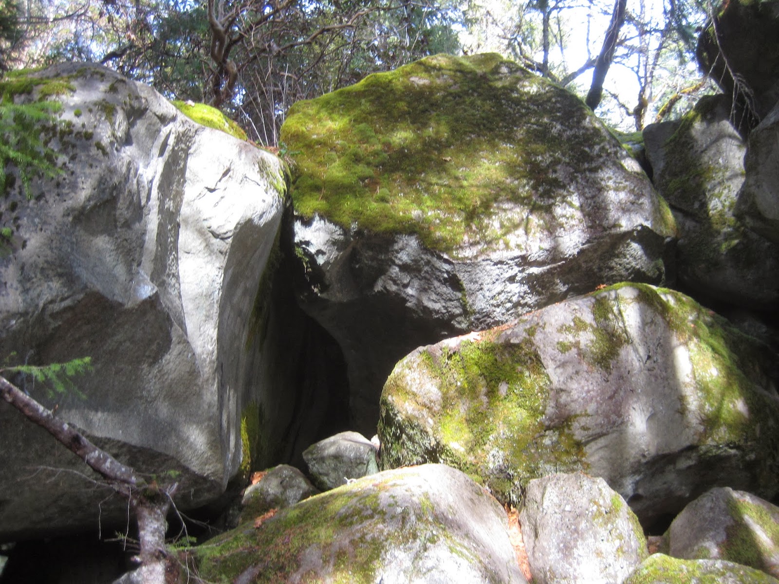
Residents along the Avenue of the Boulders

Waterfalls along Rogue River at Avenue of the Boulders

Mill Creek Falls

Barr Creek Falls

Back onto highway 62 we made one last stop at McGregor Park, which is just below Lost Creek Lake. Although the visitor center is closed, there is a short interpretive nature trail at the park.  This trail is often used by schools for field trips and includes views of a beaver den and Great Blue Heron nests.  We did not see either resident, but the trail was nice and easy with views of the Rogue River.  We hope to return to this trail sometime from February - April when the Great Blue Herons are nesting.

Bridge along interpretive trail at McGregor Park

Rogue River

Well all good things must come to an end and so we headed back home.  Our goal today was to get out and hike and to find some sunshine during winter.  So on both notes we were successful.

Since this is our last posting of 2013, we want to wish each of you a very Happy New Year!!!  We appreciate each of you who have followed our blog over the past year and enjoyed reading your comments.

We also want to say a very big THANK YOU to those of you who have listed our blog on your website and exposed us (in a good way) to others.  Also a big THANK YOU to the Friends of the Umpqua Hiking Club for letting us join you this past year on a hike at Applegate Lake.  We really enjoyed your group and hope to hike with you again in 2014.

Trekking Together
Glenn & Carol

Sunday, November 24, 2013

Prescott Park - Roxy Ann Loop

It seems like forever and a day since we last hiked.  Despite the cold temperatures, the sunshine and blue skies were too  much of a temptation for us and we took a short drive to Prescott Park to hike the Roxy Ann Loop.

The trail itself is really just a wide gravel road that circles the base of Roxy Ann.  Katie enjoys this wide gravel road because it means freedom from the leash and the ability to stop and go when she wants. We like this hike because the 4.7 mile loop gives us a nice hike without taking up our entire day and is quick to get to.

Family shadow portrait at start of the hike.
When we arrived, there were already several cars parked along the entrance road.  The first mile of the hike is a gradual incline.

And so it begins....up.....up....up.
This 1-mile segment gave us views of the Rogue Valley, Lower Table Rock and Upper Table Rock.  We eventually came to the infamous "fork in the road" and had to choose clockwise or counter-clockwise for the loop.  We went clockwise  --- seems a little easier to us, but who's cheating??

As the trail loops around Roxy Ann the landscape changes from oak trees to pine to madrone.  There are benches provided at various points allowing you to just sit and take in the great views. Almost half way through the loop we got our first view of Mount McLoughlin, which today had some snow, but was not yet completely covered in a winter coat.  Mount Ashland came into view a little later and showed very little snow coverage.
View of distant Mount McLoughlin
In addition to the loop trail we hiked, Roxy Ann/Prescott Park has numerous other trails such as the Madrone Trail, the Ponderosa Trail, etc that take you through different portions of the park and some eventually lead to the very top of Roxy Ann where you can sit among large boulders and take in an awesome view of the Rogue Valley.  With so many different options, no trail is ever crowded, which is another reason we like hiking here.

Glenn's first (and probably last) "Selfie"


Madrone tree portion of the loop


Just before completing the 2.7 loop, we walked off trail to an old tree that is the "Woodpecker Tree" of Roxy Ann.  It is really amazing with hundreds of holes, many with acorns stored away in them.  And yes, there were woodpeckers flying nearby.  We eventually rejoined the main road and hiked the last mile back to our car. Despite being a little cold when we started, we were quite warm now and feeling good after getting outside and enjoying such a beautiful day.

The Woodpecker Tree
In closing, we want to wish you and your family a very Happy Thanksgiving.
We have so much for which to be thankful!!!!

Trekking Together
Glenn & Carol


Sunday, November 3, 2013

200 Miles & RMNP Revisited

Over the past few weeks we hiked a couple of local hikes and have now reached the 200 mile mark for 2013!!

This moment came along the Jacksonville Woodland Trails and Glenn tried to create the number 200 along the trail with some large Autumn leaves.  Then a group of trail runners came by and ruined the 200 before the picture could be taken.  Glenn tried to fix the leaves but alas, a single trail runner came along and once again, the 200 was damaged.  So further along the trail Glenn created another 200, this time with pinecones along a portion of the trail where we could watch for other hikers.  Just as Glenn finished (yes you guessed it) along came a couple of hikers - but these folks were nice enough to walk around our creation and so the picture was finally taken.
The 200 mile memorial......
Of course 200 miles doesn't mean we are done for the year......we still have 2 months of hiking time left!!

We have taken some time to reflect on our hikes over the past year and we created a short video from some of the pictures/video of our time at Rocky Mountain National Park this past summer. Click on the video title below to access. Hope you enjoy.


As the year 2013 begins to wind down, we are already thinking of hikes we would love to do in 2014 and have some planned.  If you have a favorite hike, we would love to hear about it and maybe we will add it to our list of hikes for next year.

Trekking Together
Glenn & Carol