Friday, July 6, 2018

Turtle Rock Trail

June 30, 2018

Last time we visited Laramie, Wyoming, we hiked in the Vedauwoo Recreational Area along the Turtle Rock Trail.  We enjoyed it so much, that we made a point of hiking the same trail again on this visit with our daughter Maggie.

Time for another great hike!

Turtle Rock
The Vedauwoo Recreational Area is part of the Medicine Bow National Forest, but unlike a "forest", it consists of groups of unique granite rock formations.  One of the most famous being Turtle Rock. Legend states that the rocks were piled up by playful spirits and later the many nooks and crannies served as hideouts for western outlaws. Today many rock climbers practice their trade in the area and we saw a few during our hike.  Here are some of the "rock" pictures from our hike.


Ok, have to ask....is this Alfred Hitchcock or George Washington?


The 3.7 mile loop did not take long to hike, but when combined with picture taking and all the oohs and ahhs, it did take a few hours.  The best part about this loop trail is that you not only see various rock formations, but you also are treated to trails lined with wildflowers, marsh/pond areas where moose are sometimes seen, and other portions of the trail are rock or have a high desert feel.  A one word description for this trail (beside awesome) is "variety".  The Turtle Rock Trail has a little bit of everything and we once again really enjoyed this hike.

Our daughter Maggie leading the way on the trail


Trail shot

Wild Rose


One of the pond/marsh areas where moose can lurk
Having had some pretty hot temperatures over the past few days, our hike at Vedauwoo saw temps in the 60's and we finished our hike just as the rain storm started.  That's what we call great timing for a great hike! Of course after hiking the Turtle Rock Trail, we just had to go to the Turtle Rock Coffee & Cafe back in Laramie to sample their drinks and food.  That was just as good as the hike!

Trekking Together
Glenn & Carol


Thursday, July 5, 2018

Lakes Trail #296 & Miners Cabin Trail

June 29, 2018

On our recent visit to Wyoming, we took a day and drove up to the Snowy Range in the Medicine Bow National Forest to hike a couple of short trails.  This area is beautiful, even more so in person than any pictures can ever show. Plus there are many points of access and trailhead options.  What a beautiful, beautiful area to hike!

Mirror Lake

Time to hike
After parking in a small pullout area, we hiked a paved path to Mirror Lake.  From the picnic area it was just a short walk on the road to the Lakes Trail #296 TH.  The beginning elevation is around 10,000 feet, so we weren't sure how far we could hike since high altitudes tend to affect Glenn.

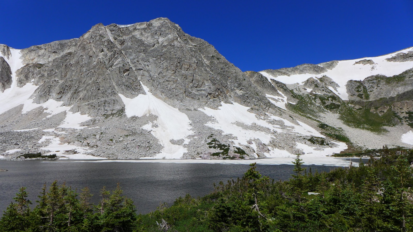
View of lake with Medicine Bow Mountains

Trail shot with view of the lake

One of many rock cairns along the trail

What a view!
As we made our way along the trail, we encountered segments of snow along the hills and lakes, but were also treated to numerous swaths of wildflowers.  Add to that mix the Medicine Bow Mountains looming above the lakes with plenty of snow and you get one incredible view throughout this hike.  Here are a few pictures of the wildflowers we saw.


We hiked along the trail until we were at about 11,000 feet and decided to turn around.  You can hike about 2.7 miles along this trail and reach Medicine Bow Peak, but the elevation started to affect Glenn so we made the 1.5 mile mark the turnaround point.  Regardless, it was an amazing hike with so much beauty!

Maggie and Chad

Carol and Glenn
After leaving that TH, we drove a few miles down the road to another trail at a lower elevation, the Miners Cabin trail.  This short loop trail took us to an old cabin that unfortunately had caved in over the winter.

Hike #2

The Miners Cabin -- a fixer upper!
 It also featured remains of the Red Mask Mine.  Along the trail there were information plaques that provided historical insights as well as information on the terrain and animals that make up this area.

The Red Mask Mine entrance area


View of Miners Cabin trail

More beautiful flowers


Even though we hiked under 4 miles for the day, we had run out of time and had worked up quiet the appetite.  As we drove back to Laramie, we stopped in the historic town of Centennial for lunch.  As we pulled up at the Mountain View Historic Hotel & Cafe, we found that they were just closing for the day. Bummer.....but wait, the owners, Mike and Kat, decided to stay open just for us!  We must have looked famished! A BIG THANKS to owners Mike and Kat!!!!  By the way, the food was delicious.  Glenn had the sirloin burger and said it was the best burger he has ever eaten.  If you make your way to Centennial, Wyoming, be sure to check out the Mountain View Cafe for a meal -- you'll love it too. If you want to stay in Centennial, they also have 6 rooms available.


So with full stomachs to go with tired legs, we headed back into Laramie.  But this was not the last of our hikes.  Up next, the Turtle Rock Trail in the Vedauwoo Recreational Area.

Trekking Together
Glenn & Carol

Sunday, June 17, 2018

Boccard Point

June 16, 2018

Over the last month we have read numerous blog postings about hiking to Boccard Point from fellow local hikers and hiking clubs.  All that psychological warfare finally took effect and we headed out for a 10+ mile hike along the PCT and Boccard Point trail to see what all the fuss was about.

Hobart Bluff TH of the PCT - notice the clouds in the background!
One of the highlights of this hike happened before we even began hiking.  As we drove the access road off highway 66 to get to the trailhead, we say deer cross the road and one remain on the road right in front of us.  We also saw something trotting along and crossing the road behind the deer.  As we got closer to the deer on the road, another animal trotted across the road ahead of us -- a wolf!  Yup, we evidently got a rare glimpse of some wolves that are in the Southern Oregon/Northern California area.  Amazing!  The deer in front of us did quickly depart - opposite direction of the wolves and our car.


Hiking into the clouds and through the wind.

Indian Paintbrush was everywhere on this hike.

Columbine also made numerous appearances along the trail
Ok, now to the hike.  When we arrived at the Hobart Bluff TH on the PCT, we were immersed in clouds and the wind was really blowing.  The first hour of our hike was like hiking at the coast.  We had double shirts and jackets on and were still freezing!  It also cut out the various views of meadows and valleys that are featured along this section of the PCT.  Fortunately many portions of the trail went through forested areas which helped to cut down the wind.

Beautiful beautiful area!

VIew of Pilot Rock from Boccard Point trail
As we finished our cloudy & windy 3 mile hike south on the PCT, we connected to the Boccard Point trail which rambles slowly uphill for 2.2 miles, finishing as one might suspect, at Boccard Point.  At times this trail was hard to follow as it appeared that no maintenance had been done recently, but as the sun came out we managed our way to the point and took time to enjoy views of Mt Shasta, the Irongate Reservoir, and Pilot Rock.  We even had our own little stone bench slightly below the point where we took a break out of the wind and enjoyed the newly arrived sunshine and blue sky.

Our natural stone bench break area.

View of Boccard Point with snow covered Mt Shasta in the distance

Trail just below Boccard Point


Usually on an out-and-back hike, the return hike is pretty much the same, just in reverse.  But since we didn't get to see much on the hike out due to clouds, the hike back provided us with lots of opportunities to see the surrounding valleys, large meadows, and enjoy many many beautiful wildflowers --  a few that were new to us.  The Soda Mountain Wilderness is an incredibly beautiful area with such diversity in wildflowers.  Pictures just don't do justice, nor words, to depict how beautiful this hike was in regards to the flora.

Heading through one of the forested areas.

Trail shot through one of many large meadows

Another beautiful large meadow just off trail
We both felt pretty good even after the 10.4 mile hike and no wolves were seen on the drive back out to highway 66.  For those of you who enjoy wildflowers, we have included some pictures from this hike at the bottom of this posting for your viewing pleasure.  Of course getting out and seeing them yourself before they are gone, is even better.  Hope you get a chance to do so.

Trekking Together
Glenn and Carol