Showing posts with label Rogue River. Show all posts

Friday, October 18, 2019

Postcards from Valley of the Rogue State Park

October 18, 2019

With Autumn in full swing here in Southern Oregon, we headed over to nearby Valley of the Rogue State Park after work to take in more sights while doing a quick hike.  If you don't like hiking or don't have a lot of time to walk, Valley of the Rogue State Park offers free day use parking and has a paved bike path and nice 1 mile trail along the Rogue River where you walk and enjoy the outdoors.  Click on the link above to access the trail and park maps. Our hike today went through the camping loops, along the Rivers Edge trail, and along some of the bike path for 3.2 miles.  Give it a try sometime and if you have time now, get there before the Autumn colors are gone.  Check out our "postcards" from today's outing.

Trekking Together
Glenn and Carol

Along the Rivers Edge trail


View of hills across the I-5 
Campground loop


More campground loop Autumn color

One of the trees that has shed all it's leaves already


One of our favorite large Autumn yellow trees in the park

Monday, May 6, 2019

Upper Rogue and Pearsony (or Pearsoney?) Falls


May 5, 2019

Temperatures in the valley were on the rise and with all the snow melted, Union Creek was calling our name.  We took Katie and hiked the Upper Rogue trail from Woodruff Bridge to the Natural Bridge.  This section had a mix of slow moving river and fast, churning white water as the river is very full from all the snow melt.  We made a couple of stops along the trail to explore and get a closer look at some falls, and once at the Natural Bridge Day Use Area we checked out all the viewpoints even though the Natural Bridge was under water.  When we completed our hike along the Upper Rogue, we drove to Prospect and hiked to Pearsoney Falls and a viewpoint of the water cascades coming down the Avenue of the Boulders.  Both were amazing with all of the water!  We thought about stopping to view Mill Creek Falls and Barr Falls, but is was getting hot and with 9.4 miles in the book, we headed home where we enjoyed sandwiches from the Picnic Basket Deli in Shady Cove.  This hike also put us over the 200 mile mark for the year.  Who knows, maybe we will hit 500 miles this year.

Trekking Together
Glenn & Carol


The cascade at Woodruff Bridge where we started our hike.
Dogwood trees were in bloom.

Another cascade about 2 miles into our hike.

Trillium's were numerous along the trail along with Calypso Orchids


Sign has Pearsoney but Oregon State Parks has is as Pearsony - who is right?


Pearsoney Falls.  Notice the falls to the left due to so much water.
View of Rogue River cascading down to the Avenue of the Boulders


Sunday, October 29, 2017

River's Edge Trail and Rogue River Greenway

October 29, 2017

As daylight savings time approaches and autumn colors begin to fade, it was time for one more  hike to enjoy the color and sunshine of autumn.

Time for some hiking along the Rogue River at Valley of the Rogue State Park
We drove highway 99 from Medford to Valley of the Rogue State Park so we could enjoy a last autumn drive only to find that most of our drive was in fog.  As a matter of fact, our entire hike on the River's Edge trail and along the Rogue River Greenway to our turnaround at the Depot Street Bridge was in fog and clouds.

Adding a little excitement for our hike.

Despite the fog, the Rogue River is still beautiful with some autumn color added.

Wooden carved dog at the pet waste box at Depot Street Bridge

Our turnaround spot - Depot Street Bridge
On our return hike though, the fog and clouds burned off and the sun and blue sky took over.

Blue sky and autumn yellow!


View along the Rogue River Greenway


We saw lots of autumn yellow, especially on the River's Edge trail through Valley of the Rogue State Park.

Yellow, yellow, yellow!

View of River's Edge trail covered & surrounded by yellow.


It was a very nice 6.8 mile hike and we enjoyed what will probably be our last autumn hike with color.  Hope you got our to enjoy the season with a walk in the neighborhood, at a park or on a trail.

Trekking Together
Glenn & Carol

Monday, December 12, 2016

Rogue River Greenway - Rivers Edge Trail

December 11, 2016

With all the recent rains, fighting illnesses, and Glenn's busy time at work, we haven't got out to hike as often as we would like, but we hit the 300 mile mark for the third year in a row when we hiked the Rogue River Greenway and Rivers Edge Trail at theValley of the Rogue State Park.

Time for another hike!!
We parked in the Valley of the Rogue Rest Area and walked down to the paved Rogue River Greenway to begin our hike.  We hiked along the Greenway towards the State Park till we came to the intersection with the Rivers Edge Trail off to the left..  We have hiked this trail many times and enjoy the fact that you hike along the Rogue River and get treated to many views as well as access trails down to the rivers edge.  On our hike today we were treated to views of three Blue Herons along the shore, but were unable to get a real good picture.

HIking along the Rogue River Greenway

Can you see the Blue Heron across the river?  Rivers edge in front of the second tree acorss the river.

Beavers are still busy this time of year!


After about a mile, the Rivers Edge Trail rejoins the Rogue River Greenway and heads outside the State Park  boundaries and towards the town of Rogue River and Grants Pass.  Today we hiked almost to Rogue River before turning around and retaracing out steps back to the rest stop and our car.

Autumn leaves are gone, but still pretty.
Along the way we were treated to views of the river, some nice foreested sections, and a display of multiple rock cairns alongside the trail.  We did meet a few other hikers out today and some folks bicycling the Greenway despite the cold and cloudy weather.

One the many birdhouses along the Greenway

Scary beaver mile marker!

One of the carins along the Greenway


The hardest part about today's hike was hiking next to the campground at the State Park and smelling the campfires, wishing we could join some folks at their campsite!!  It was great to get out again and as mentioned earlier, to get to the 300 mile mark.

300 MILES written out on the Greenway!!

The fast, high and murky Rogue River
There are still a few weeks left in the year and we are hoping to get out and hike a few more times to add to the mileage total.  Then it will be 2017 and time to start over again on a whole new set of hiking adventures and miles.  We can hardly wait!

Trekking Together
Glenn & Carol

Monday, October 24, 2016

Upper Rogue River Trail: Woodruff Bridge - River Bridge

October 22, 2016

Autumn beauty also means autumn weather.  So it took a few weeks to finally get out and enjoy the beautiful colors that make autumn our favorite season.


We drove to the Woodruff Bridge Picnic Area located near Union Creek and met the Friends of the Umpqua Hiking Club for a 9-ish mile hike along the Upper Rogue River Trail. This section of the trail provides you with many views of the Rogue River, autumn color along the river and trail, great starting and turnaround points (River Bridge Campground & Woodruff Bridge Picnic Area), very little elevation change, and then almost in the middle of the hike is the Takelma Gorge - a destination in itself.  It is a wonderful section to hike in either direction and one that we have hiked many times and at different times of the year.

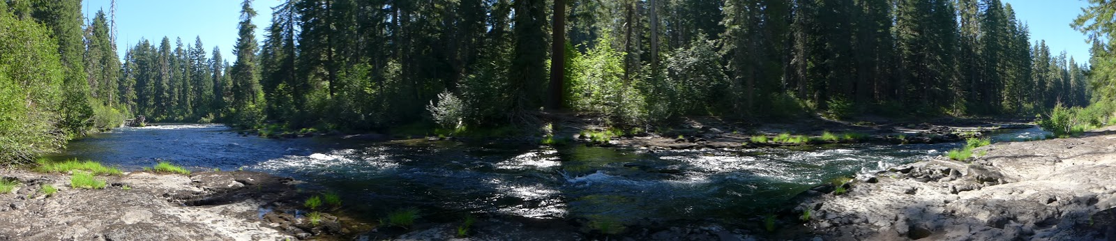
Rogue River at Woodruff Bridge - the start of our hike.
For today's hike we headed south from Woodruff Bridge.  The Rogue river became so quiet at times, one would not even know they were hiking next to it, then the river would pick up speed and remind us that it was still there.  Our trail would wind along the river shore, at times almost too close, as we saw large trees that once stood on the shore now fallen over into and across the river. The woods along the trail were very thick with undergrowth that had changed to autumn yellow and since the weather was still mild enough, mushrooms of various shapes, sizes and colors also decorated our hike.  One pair of mushrooms even got into the autumn spirit with red color and was our favorite fungus of choice.

Our favorite fungi on the hike!!
Just before the 2 mile mark the river really picks up speed as it narrows and begins it's journey through Takelma Gorge.  Although water levels are lower at this time of year, Takelma Gorge is still an amazing sight to see and always worth the short hike for viewing.  If you really want to see the gorge at it's best, take this hike in early spring as rains and melting snow fill the river and thunder through the gorge.  Just look at how high some logs are that got stuck in the gorge.

Takelma Gorge

After passing the gorge, the trail meanders towards and then away from the river, winding through the woods and kept us in the shade most of the hike.  This is great when it is summer, but today the temperature was 42 degrees when we started hiking and the sun did not come out too often.  So our hiking pace was steady to keep us moving and warm.

Autumn color along the Rogue River

Leaves like this were a constant carpet on this hike
Once we reached the River Bridge Campground, our group found a picnic table at a campsite and took a much welcomed rest & food break.  It gave us the opportunity to meet some members of the club, share hiking stories, and of course it gave Katie a chance to beg for bannans and other treats -- to which end she was successful.
The Rogue River just above the River Bridge area

Although our hike back was along the same trail, it always amazes us how different things look from another direction.  We also ran into 3 other groups of hikers out on the trail which was great to see.  Our 9-ish mile hike took around 5 hours with breaks and picture taking.  We enjoyed talking with the folks from the Friends of the Umpqua Hiking Club before, during and after the hike and hope to hook up with them again in the near future.  Thanks for letting us hike with you!!!!!  If you live in or around the Roseburg area, be sure to check out their website for their hikes every other Saturday.

The Friends of the Umpqua Hiking Club
Be sure that  you too get out and visit a park or walk around the neighborhood while the colors of autumn are still around!!  Don't let the season pass you by - enjoy it!!!

Trekking Together
Glenn & Carol


Friday, August 12, 2016

Upper Rogue Trail: Natural Bridge

July 31, 2016

As July was coming to an end, we decided to squeeze in one more hike before the month of August arrived with it's typical hot temperatures and wildfire smoke.  So off to the Union Creek area we drove about the time the Bybee fire near Crater Lake started. Yup, August is a comin'.

TIme for another hike
The Upper Rogue trail spans 41 miles from Prospect to the Mt Mazama rest stop and for the most part follows the Rogue River through calm and fast waters.  We have hiked serveral portions, but today we wanted to hike the section from the Natural Bridge parking lot towards the Big Bend TH.  It would be a oneway trip of 7 miles, 14 for an out and back.  We decided to try and hike halfway, take a break and then return.  That was our plan.....

One of our first views of the Rogue River....beautiful!

One of the calm water sections 


We began by hiking the Rogue Gorge trail from the parking lot which took us along the outskirts of the Natural Bridge campground.  Since we started early, we could smell the morning campfires and even the hint of bacon being cooked for breakfast.  But we continued on and did not crash anyone's campsite.

Bridge crossing just above the Natural Bridge campground
Eventually we crossed the Rogue River via a bridge and connected with the Upper Rogue trail to continue our hike.  The river was still very full and made for some beautiful small waterfalls and fast water, especially in some of the areas created by collaspsed lava tubes courtesy of Mt Mazama.

One of the collasped lava tube areas

Small waterfall below the lava tube area

Another beautiful cascade on the Rogue River


As we progressed along the trail, the trail itself became "less maintained" shall we say.  We encounted a couple of downed trees, then overgrowth along the trail, followed by a very overgrown meadow where tht trail had only been maintained by the local cow population.  It is a scary thing to step along a trail you cannot see and know that cows have been there too.....it is only a matter of time till you step on what those cows left behind.  Of course the overgrowth on the trail was especially tough on Katie, since she is only a few feet above the ground!  So when the trail disappeared in the overgrowth which was above our heads, we stopped and turned around.  Just take a look and see if  you can find the trail below!

Where oh where did the trail go???
On our return leg we did stop at a spot we had seen earlier where a rocky flat area meets the river.  We got to enjoy great views up and down the river and Katie even took a few quick dips.

Panoramic view of our break area next to the river
When we came to the bridge that we had crossed earlier, we continued on the Upper Rogue trail which took us by the Natural Bridge viewing area and eventually to the parking lot.  The Natural Bridge Falls just below the Natural Bridge area was very full of water and beautiful.

The Rogue River exiting from under the Natural Bridge

The Natural Bridge Falls
We didn't hike as far as we wanted to, but were still treated to great views of the beautiful Rogue River.  And we didn't even notice the smoke from the Bybee fire.  Hopefully that is an omen for hiking in August.

Trekking Together
Glenn & Carol