Showing posts with label Union Creek. Show all posts

Saturday, July 11, 2020

Upper Rogue River Trail #1034 - Natural Bridge to Takelma Gorge

July 8, 2020

We continued with our "wandering Wednesdays" this week with a trip to the Union Creek area.  We took Katie and drove to and parked in the Natural Bridge Day Use area to hike a section of the Upper Rogue River  #1034 trail.

Time to hike on a "wandering" Wednesday

View of the Natural Bridge area
 After taking a short hike to view the Natural Bridge area from the man-made bridge over the Rogue River, we began our trek south along the Upper Rogue River trail.  We hiked past Knob Falls, through the Woodruff Bridge area and made our way to our turnaround point, Takelma Gorge.

Lots of Prince's Pine on this hike

Takelma Gorge, our lunch and turnaround point
Along the way we had great views of the beautiful Rogue River, saw a pair of doe's with fawns along the shoreline, osprey and blue heron flying along the river, and were treated to lots of Prince's Pine, Twin Flowers, Wintergreen, Candystick, Wild Roses and Horsemint too.

The beautiful Rogue River

Candystick
The section from Natural Bridge to Woodruff Bridge did have a number of trees across the trail due to lack of trail maintenance this year, and on the section from Woodruff Bridge to Takelma Gorge we had a few sections of trail that were completely overgrown with shrubs.  Made for some interesting navigation.

Tree blockage along the trail.....

....and overgrown shrubs on other sections of trail.


At Takelma Gorge we took a nice break on some stone ledges to enjoy the sound and view of this area.  We only saw a few other hikers throughout our trek.  Weather was great, although towards the end of our 10.5 mile hike the temps were starting to get up in the low 80's and by then were we tired.  Still it was a great day & an incredible hike along a beautiful river.  Beats work anytime!

Trekking Together
Glenn and Carol


Monday, May 6, 2019

Upper Rogue and Pearsony (or Pearsoney?) Falls


May 5, 2019

Temperatures in the valley were on the rise and with all the snow melted, Union Creek was calling our name.  We took Katie and hiked the Upper Rogue trail from Woodruff Bridge to the Natural Bridge.  This section had a mix of slow moving river and fast, churning white water as the river is very full from all the snow melt.  We made a couple of stops along the trail to explore and get a closer look at some falls, and once at the Natural Bridge Day Use Area we checked out all the viewpoints even though the Natural Bridge was under water.  When we completed our hike along the Upper Rogue, we drove to Prospect and hiked to Pearsoney Falls and a viewpoint of the water cascades coming down the Avenue of the Boulders.  Both were amazing with all of the water!  We thought about stopping to view Mill Creek Falls and Barr Falls, but is was getting hot and with 9.4 miles in the book, we headed home where we enjoyed sandwiches from the Picnic Basket Deli in Shady Cove.  This hike also put us over the 200 mile mark for the year.  Who knows, maybe we will hit 500 miles this year.

Trekking Together
Glenn & Carol


The cascade at Woodruff Bridge where we started our hike.
Dogwood trees were in bloom.

Another cascade about 2 miles into our hike.

Trillium's were numerous along the trail along with Calypso Orchids


Sign has Pearsoney but Oregon State Parks has is as Pearsony - who is right?


Pearsoney Falls.  Notice the falls to the left due to so much water.
View of Rogue River cascading down to the Avenue of the Boulders


Tuesday, May 30, 2017

Union Creek Trail - The 11 Year Curse

May 28, 2017

Eleven years ago, back in 2006, we had just begun to make hiking a regular part of our life.  That  year we hiked 16 times for a total of 53.9 miles. The longest hike by far was in October when we hiked the Union Creek Trail in hopes of seeing Union Creek Falls - which we did not, due to the water being so low since it was late in the year.  We didn't do any posting of our hikes back then and we didn't even have a digital camera!  How times have changed.

Time to hike
So here we are in 2017 with almost 2,000 miles of hiking under our belts and we figured it was about time to try the Union Creek Trail again and see the falls. After all, there should be plenty of water in the creek from this winter and spring!

Vanilla Leaf was a constant companion on this hike
After arriving at the trail head located on highway 62,  we started our hike only to run into another couple heading our direction, They informed us that the bridge leading over the creek was gone and that we would have to go back to highway 62 and hike around the store and a few cabins to pick up the trail on the other side.  This in itself should have set off bells and whistles, but on such a beautiful day and with the creek full and more like a river in appearance, we continued on.

One of many trees that fell across Union Creek this winter
Union Creek looking more like a river.


As we found the trail and continued on, the first couple of miles were very nice.  The creek was beautiful and stayed within sight of the trail as we navigated around or over a few down trees with no problem.  But then the fun began. (Jaws music please)  The next couple of miles turned into an adventure as the few down trees became groupings of down trees mixed with brush.  We climbed over, got on all fours to crawl under, and in many cases made wide detours to get around the trail blockage.  Some portions of the trail were under water or completely washed away.  Oh yeah, and the mosquitoes took advantage of any stops we made while trying to figure out the trail route.  Katie of course seemed to enjoy all of this and saw no problem going under, over or around the trees and could always find her way back to the trail.  Mud and water on the trail - just walk in and through it.  And so she did.

One of the many small waterfalls along Union Creek
We eventually came to a very large side creek and had to cross by tightrope walking on a very large fallen tree that went over the creek.  When we came to a second log crossing of a side creek, Glenn found out that not all logs are sure and steady and proceeded to cool off his leg and foot in the creek as the log rolled.  At this point we were at the 3.3 mile mark on the trail even though our mileage was now up to 4 miles due to detours. We stopped and took a break beside the creek at a nice 7-foot waterfall.  No, it was not the Union Creek Falls.  That was still almost another mile up the trail.

Looking downstream at our turnaround spot on the trail.

Looking upstream at our turnaround spot on the trail.


After cooling off and catching our breath, we decided to call off our pursuit of the falls and head back, knowing that if we continued on we would be hiking close to 10 miles and that it would take another 3-4 hours to finish hiking.  So back we went through the same log crossing - under water and washed away - tree and shrub blocked detours again.  By the time we got back to the trailhead, we were very tired, hot and scratched up. We bought a couple of ice cold sodas at the store and sat down on a bench to take in the view of Union Creek once more before leaving.  After all, we probably won't hike this trail again for another 11 years.

Trekking Together
Glenn & Carol


Friday, August 12, 2016

Upper Rogue Trail: Natural Bridge

July 31, 2016

As July was coming to an end, we decided to squeeze in one more hike before the month of August arrived with it's typical hot temperatures and wildfire smoke.  So off to the Union Creek area we drove about the time the Bybee fire near Crater Lake started. Yup, August is a comin'.

TIme for another hike
The Upper Rogue trail spans 41 miles from Prospect to the Mt Mazama rest stop and for the most part follows the Rogue River through calm and fast waters.  We have hiked serveral portions, but today we wanted to hike the section from the Natural Bridge parking lot towards the Big Bend TH.  It would be a oneway trip of 7 miles, 14 for an out and back.  We decided to try and hike halfway, take a break and then return.  That was our plan.....

One of our first views of the Rogue River....beautiful!

One of the calm water sections 


We began by hiking the Rogue Gorge trail from the parking lot which took us along the outskirts of the Natural Bridge campground.  Since we started early, we could smell the morning campfires and even the hint of bacon being cooked for breakfast.  But we continued on and did not crash anyone's campsite.

Bridge crossing just above the Natural Bridge campground
Eventually we crossed the Rogue River via a bridge and connected with the Upper Rogue trail to continue our hike.  The river was still very full and made for some beautiful small waterfalls and fast water, especially in some of the areas created by collaspsed lava tubes courtesy of Mt Mazama.

One of the collasped lava tube areas

Small waterfall below the lava tube area

Another beautiful cascade on the Rogue River


As we progressed along the trail, the trail itself became "less maintained" shall we say.  We encounted a couple of downed trees, then overgrowth along the trail, followed by a very overgrown meadow where tht trail had only been maintained by the local cow population.  It is a scary thing to step along a trail you cannot see and know that cows have been there too.....it is only a matter of time till you step on what those cows left behind.  Of course the overgrowth on the trail was especially tough on Katie, since she is only a few feet above the ground!  So when the trail disappeared in the overgrowth which was above our heads, we stopped and turned around.  Just take a look and see if  you can find the trail below!

Where oh where did the trail go???
On our return leg we did stop at a spot we had seen earlier where a rocky flat area meets the river.  We got to enjoy great views up and down the river and Katie even took a few quick dips.

Panoramic view of our break area next to the river
When we came to the bridge that we had crossed earlier, we continued on the Upper Rogue trail which took us by the Natural Bridge viewing area and eventually to the parking lot.  The Natural Bridge Falls just below the Natural Bridge area was very full of water and beautiful.

The Rogue River exiting from under the Natural Bridge

The Natural Bridge Falls
We didn't hike as far as we wanted to, but were still treated to great views of the beautiful Rogue River.  And we didn't even notice the smoke from the Bybee fire.  Hopefully that is an omen for hiking in August.

Trekking Together
Glenn & Carol

Monday, April 27, 2015

Upper Rogue Trail

April 18, 2015

Since warmer temperatures were in the forecast, we decided to drive up to the Union Creek area and stretch our legs (and Katie's) for a long and beautiful hike along the Rogue River


The Upper Rogue trail stretches over 40 miles along the Rogue River.  One end is at the Mount Mazama Viewpoint in the north, the other end is at the Prospect Reservior Park in the south.  In between there are various access points that allow for short or long day hikes.  We chose the 
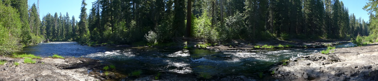
Woodruff Bridge Picnic area for our access on today's hike.

We began by hiking from our car to the Woodruff Bridge and seeing the beautiful falls directly upstream.  Not sure if the falls have a name or not, but Woodruff Falls would seem like a good name.  We then began our trek that would take us from Woodruff Bridge south to the River Bridge Campground and back again.

Within the first mile we encountered two places where large trees had fallen into the river and taken with them large amounts of the riverbank, including the trail!  We worked our way around these areas and rejoined the trail without having to do too much bushwhacking.

Even though the Rogue River is a little low for this time of year, it was still very beautiful to hike along this scenic river and enjoy the fresh smell of the woods.  It didn't take long for the noise of the river to increase as we arrived at the beginning of Takelma Gorge.

View of the beginning of the Takelma Gorge from 2014 hike
We took a break to enjoy the viewpoint and did notice  a few new logs at the beginning of the gorge that had been washed downstream over the winter.  The trail at this point became very rocky as we hiked up above the gorge, but always within sound of the rushing water below.

After the gorge segment we enjoyed hiking on softer ground and were treated to a few wildflower varieties: small white trilliums, yellow woodland violets,  snow queen, and even some fairy slipper orchids.  The British Soldiers that we saw last year when hiking with our friend Richard, were present as well.

Faily Slipper Orchids

Snow Queen

Trillium

Yellow Woodland Violets


We arrrived at the River Bridge CG after 2 hours of hiking and found an empty campsite where we could sit down, eat, and enjoy a nice break.  In Katie's opinion, the salmon jerky was the best item for lunch, followed closely by a banana.

Once rested and refreshed, we began our return hike to Woodruff Bridge.  One highlight of the hike back was seeing a Pileated Woodpecker fly by and land on a tree within viewing distance.  We have seen these very large woodpeckers a couple of times while hiking Roxy Ann, but never along the Rogue River.

After our two hour hike back to Woodruff Bridge, we decided to continue on the trail and hike a few extra minutes north.  As a result we finished our hike at 10.1 miles -- our first 10+ mile hike of the year.  A long hike -- a beautiful river -- temperatures in the 70's.  What a great day!

Trekking Together
Glenn & Carol